KOGD

OGDEN-HINCKLEY
OGDEN
UT
Time Zone: Mountain
Lat: N 4111.7
Long: W 11200.7
Elev: 4473
Var: -11
Longest Runway: 8107
Dept. ATIS: 125.55
Arr. ATIS: 125.55
AWOS: 125.55
Ground: 121.7
Tower: 118.7

FBO & Flight Services info for KOGD

FBOs: Update your Fuel Prices

  click here  
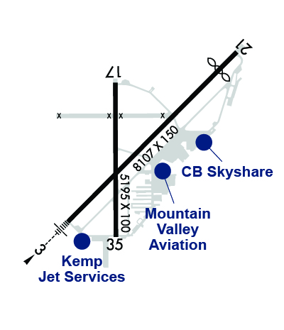
Kemp Jet Services is a full-service, luxury FBO serving the greater Salt Lake City region. Only 25 minutes from downtown Salt Lake City, Kemp Jet Services offers a variety of pilot, aircraft, and passenger amenities. As a member of the Avfuel FBO Network, Kemp Jet Services offers Avfuel Contract Fuel for jet fuel savings as well as AVTRIP rewards points on qualifying fuel purchases.
Ph: 801-627-0040 Fax: 801-627-6286 Freq: 122.95WebsiteE-Mail
                   
Service
Jet
100LL
SAF
MoGas
Fuel Avail: INJECTED PRIST IF REQUIRED. 7 Days a week 0700-2000 Call out available after hours.
Full6.306.90    Last Update: 04/17/2024 13:03

Self        
Misc. Info: Volume DiscountsAddress: 4282 SOUTH 1650 WEST   OGDEN, UTAH 84405
This incomparable FBO lies at the base of the Wasatch Mountains, only 5 air miles from the slopes of Sun Valley Snowbasin Resort, the world renown site of the 2002 Winter Olympics...Highly stylized executive terminal, with its warm atmosphere.
Ph: 801-394-3400 Fax: 801-394-9563 Freq: 122.95WebsiteE-Mail
Service
Jet
100LL
SAF
MoGas
Fuel Avail: 0700-2000 7 Days
Full6.306.90    Last Update: 04/17/2024 13:06

Self        
Misc. Info: Address: 3911 AIRPORT RD   OGDEN, UT 84405

CB SKYSHAREPh: 801-621-0326 Fax: 801-645-9896 Freq: 122.95
Service
Jet
100LL
SAF
MoGas
Fuel Avail: PRIST + $0.05/gal., 7A-8P, 7 DAYS. Call outs available by request
Full6.306.60    Last Update: 03/26/2024 14:08  
Self  6.40    
 Address: 3715 AIRPORT RD.   OGDEN, UT 84405
ASOSPh: 801-622-5600
-
Freq: 125.55  
If you are an FBO, call 1-203-262-1700 to update your info or email: FltPlan.Advertising@garmin.com
Advertise your FBO on FltPlan.com

Runway & Approach Info for KOGD
Rwy
Length
Land Dist**
Approach*
  Rwy
Length
Land Dist**
Approach*
03
8107x150  8107'          
ILS/DME
 111.70 - 033°  
  
21
  8107x150  7253'          
 
17
5195x100  5195'          
 
  
35
  5195x100  5195'          
 
 * only ILS, LOC, LDA, and SDF approaches to a specific runway are shown
** For any Declared Landing Distance Available, please see A/FD or Approach plates
Runway Weight Capability (lbs.) Help
Runway IDSingle WheelDouble WheelDouble Tandem WheelDual Double Wheel
03/2185,000150,000N/AN/A
17/3580,000140,000N/AN/A
These numbers are Advisory and are not limits.   The Airport Manager should have more accurate Weight Limits
Approach Charts
Approaches    
Current Weather/Notams
Customs Information Send updates to Support@FltPlan.com
Customs Not Available
Database effective 05/16/2024
Airport Diagram of KOGD
Airport Diagram might not be current.

Facility Name: OGDEN-HINCKLEY
City Name: OGDEN
County: WEBER
State abbrev: UT
State Name: UTAH
   
Ownership: PUBLICLY OWNED
Use: OPEN TO THE PUBLIC
Owner's Name: OGDEN CITY CORPORATION
Address: 2549 WASHINGTON BLVD
 OGDEN, UT 84401
Owner's Phone: 801-629-8223
  
Manager's Name: BRYANT W GARRETT, AAE
Address: 3909 AIRPORT ROAD
 ODGEN, UT 84405
Phone: 801-629-8223
   
FAA Region: NORTHWEST MOUNTAIN
FAA Field Office: DEN


Sunrise / Sunset times for OGDEN-HINCKLEY

DateSunriseSunset
04/24/24 Wednesday6:3420:19
04/25/24 Thursday6:3320:20
04/26/24 Friday6:3120:21
04/27/24 Saturday6:3020:22
04/28/24 Sunday6:2920:23
04/29/24 Monday6:2720:24
04/30/24 Tuesday6:2620:25
05/01/24 Wednesday6:2520:26
05/02/24 Thursday6:2320:27
05/03/24 Friday6:2220:28
05/04/24 Saturday6:2120:29
05/05/24 Sunday6:2020:30
05/06/24 Monday6:1820:31
05/07/24 Tuesday6:1720:32

Airport Facilities

Airport Attendance ScheduleCONTINUOUS; ARPT SFC COND UNMON 2000-0700.
Airport Status OPERATIONAL (This Status can change at any time - please check NOTAMS)
Airport Lighting ScheduleWHEN ATCT CLSD ACTVT MALS RWY 03; REIL RWY 17 & 35; PAPI RWY 03 & 21, 17 & 35; HIRL RWY 03/21; MIRL RWY 17/35; TWY LGTS - CTAF.
Airport Storage AvailableTie Downs, Hanger
Extra Services AvailableCrop Dusting, Avionics, Charter, Flight Instruction, Parachute Jumping, Aircraft Rental, Aircraft Sales, Annual Surveying
Wind IndicatorYES - (lighted)
Control TowerYES
CTAF Frequency118.700
Unicom Frequency122.950
Rotating Beacon ColorWG
Segmented CircleYES
Landing FeeYES; ACFT IN EXCESS OF 12,500 LBS.

Airport Inspection Data

Airport InspectedFEDERAL - performed by FAA AIRPORTS FIELD PERSONNEL
Inspection Date08/07/2023

Airport Services

Type of Fuel AvailableGrade 100, Grade 100LL, JET A-1 (icing inhibitor, freeze point -50C)J; -J JP4
Airframe Repair ServiceMAJOR
Power Plant Repair ServiceMAJOR

Geographic Data

LatitudeN4111.7
LongitudeW11200.7 (ESTIMATED)
Arpt Elevation4472ft (SURVEYED)
Magnetic Variation11E
3 miles SWof OGDEN
Traffic Pattern AltitudeTPA 5200 MSL REQD DUE TO INTERFACING TFC FM HILL AFB.
Sectional ChartSALT LAKE CITY

Aircraft Data

Operations (Reported)YearlyAvg. Daily
General Aviation Transient 59751164
General Aviation Local 44107121
Air Taxi 369110
Commerical 2321
Commuter 00
Military 2421
Aircraft based on Field
General Aviation Singles 191
General Aviation Multi 25
Jet Aircraft 8
General Aviation Helicopters 12
Military Aircraft 0
Gliders 2
Ultralights 3

FAA Services

FSS on field NO
FSS tie-in CEDAR CITY
FSS Phone 1-800-WX-BRIEF
Who issues Notams OGD
Notam D service at airport YES
ARTCC Name SALT LAKE CITY

Federal Status

Airport CertificationAIRPORT RECEIVING SCHEDULED AIR CARRIER SERVICE FROM CARRIERS CERTIFICATED BY THE CIVIL AERONAUTICS BOARD; CLSD TO ACFT OPS WITH MORE THAN 30 PSGR SEATS EXC PPR; MNM 6 HR PPR, CALL AMGR 801-629-8223/336-7459/710-3706.
Aircraft Rescue & Firefighting IndexAIRPORT HAS A CERTIFICATE UNDER CFR PART 139
Airport of EntryNo
Custom Landing RightsNo
Joint Civil/MilitaryNo
Military Landing rightsYES

Federal Agreements

NATIONAL PLAN OF INTEGRATED AIRPORT SYSTEMS (NPIAS)
GRANT AGREEMENTS UNDER FAAP/ADAP/AIP
ASSURANCES PURSUANT TO TITLE VI, CIVIL RIGHTS ACT OF 1964
AGREEMENT UNDER DLAND OR DCLA HAS EXPIRED.

Remarks

NO MULTIPLE APCHS. NO PRACTICE APCHS - FULL STOP LANDINGS ONLY FROM 2200-0700.
PARACHUTE JUMPING ON NE PORTION OF AIRPORT EAST OF TWY A.
NO SNOW REMOVAL AFTER ATCT CLOSES.
HVY VOL OF MILITARY ACFT FLYING OVER OGDEN ARPT AT 5700-6300 FT MSL, ENROUTE TO HILL AFB.
FOR CD WHEN ATCT IS CLSD CTC SLC APCH AT 801-325-9670.
RWY 03/2 1 ST 152
Airport Communications & Frequencies:
ATIS Frequencies:   Hours(local) of Operation: CONTINUOUS
125.55
OGDEN Tower Frequencies:   Hours(local) of operation: 0700-2000   
118.7
253.5
OGDEN Ground Frequencies:
121.7
CTAF Frequency:
118.700
Unicom Frequency:
122.950
Remarks
  • FREQ 121.5 NOT AVBL.
  • SALT LAKE CITY Primary Approach Frequencies:  
    121.1
    SALT LAKE CITY Primary Departure Frequencies:  
    121.1
    Class B Frequencies:
    319.25 NORTH OF 41 DEG LAT
    Runway Identifications
    Runway Identification: 03/21
    Length: 8107 ft
    Width: 150 ft
    Surface: ASPHALT
    Edge lights: High Intensity

    Treatment: GROOVED

     Runway: 03   Runway: 21
    Mag heading: 33°Mag heading: 213°
    Rwy Slope: -.78% DownRwy Slope: .78% Up
    Approach: ILS/DMEApproach:
    Pattern: Left TrafficPattern: Right Traffic
    Markings: PRECISION INSTRUMENTMarkings: NONPRECISION INSTRUMENT
    Marking Condition: GOODMarking Condition: GOOD
    Arresting Dev: Arresting Dev:
    Lat & Long: N4111.3  W11201.2Lat. & Long.: N4112.2  W11200.0
    Elev: 4472.5 ft. MSLElev: 4409.0 ft. MSL
    TCH: 56 ft. AGLTCH: 50 ft. AGL
    Visual Glide Path: 3.00 degreesVisual Glide Path: 3.00 degrees
    Displaced Threshold: NoDisplaced Threshold: 854 feet
    Touchdown Zone: YESTouchdown Zone: YES
    Touchdown Elev.: 4472.5 feetTouchdown Elev.: 4438.3 feet
    Visual Glide Slope: 4-Light PAPI on LEFT side of RunwayVisual Glide Slope: 4-Light PAPI on LEFT side of Runway
    RVR Equipment: RVR Equipment:
    RVV Equipment: NORVV Equipment: NO
    Approach Lights: MALS - 1,400 foot medium intensity approach lighting systemApproach Lights:
    REIL: NOREIL: NO
    Centerline Lights: NOCenterline Lights: NO
    Touchdown lights: NOTouchdown lights: NO
    Runway Category: Precision Instrument RunwayRunway Category: Runway with a Visual Approach
    Declared Distances: TORA:8103' TODA:8103' ASDA:7252' LDA:7252'Declared Distances: TORA:8103' TODA:8103' ASDA:8103' LDA:7252'
    Obstructions: TREESObstructions: POLE
    Marked: NOT Marked/LightedMarked: NOT Marked/Lighted
    Clearance slope: 44:1Clearance slope: 34:1; APCH SLOPE 77:1 TO DTHR.
    Obstruction height: 54 feet AGLObstruction height: 24 feet AGL
    Dist. from runway: 2425 feetDist. from runway: 1017 feet
    Centerline offset: 305 left of centerlineCenterline offset: 161 feet left of centerline
    Comments: Comments: 17 FT ROAD 350 FT FM THR.
    Runway Identification: 17/35
    Length: 5195 ft
    Width: 100 ft
    Surface: ASPHALT-GOOD CONDITION
    Edge lights: Medium Intensity

    Treatment: GROOVED
    Weight: PCN 63 /F/A/X/T

     Runway: 17   Runway: 35
    Mag heading: 168°Mag heading: 348°
    Rwy Slope: .40% UpRwy Slope: -.40% Down
    Approach: Approach:
    Pattern: Right TrafficPattern: Left Traffic
    Markings: BASICMarkings: BASIC
    Marking Condition: GOODMarking Condition: GOOD
    Arresting Dev: Arresting Dev:
    Lat & Long: N4112.1  W11200.9Lat. & Long.: N4111.2  W11200.9
    Elev: 4436.4 ft. MSLElev: 4457.4 ft. MSL
    TCH: 50 ft. AGLTCH: 50 ft. AGL
    Visual Glide Path: 3.00 degreesVisual Glide Path: 3.00 degrees
    Displaced Threshold: NoDisplaced Threshold: No
    Touchdown Zone: YESTouchdown Zone: YES
    Touchdown Elev.: 4450.4 feetTouchdown Elev.: 4457.5 feet
    Visual Glide Slope: 4-Light PAPI on LEFT side of RunwayVisual Glide Slope: 4-Light PAPI on LEFT side of Runway
    RVR Equipment: RVR Equipment:
    RVV Equipment: NORVV Equipment: NO
    Approach Lights: Approach Lights:
    REIL: YESREIL: YES
    Centerline Lights: NOCenterline Lights: NO
    Touchdown lights: NOTouchdown lights: NO
    Runway Category: Runway with a Visual ApproachRunway Category: Runway with a Visual Approach
    Declared Distances: TORA:5195' TODA:5195' ASDA:5195' LDA:5195'Declared Distances: TORA:5195' TODA:5195' ASDA:5195' LDA:5195'
    Obstructions: ROADObstructions: SIGN
    Marked: NOT Marked/LightedMarked: NOT Marked/Lighted
    Clearance slope: 3:1Clearance slope: 20:1
    Obstruction height: 3 feet AGLObstruction height: 50 feet AGL
    Dist. from runway: 210 feetDist. from runway: 1200 feet
    Centerline offset: 125 right of centerlineCenterline offset: 200 feet right of centerline
    Comments: Comments:
    C:44/P: